
Once again the ticket machines at Kings Cross where not working properly, several folk had failed to get their tickets and the situation was not helped by a rather rude and abrupt gent at the ticket counter. Thankfully a few people had taken his name and where going to file a complaint.Thankfully my train was not cancelled, however, a points failure outside of Doncaster saw us running some twenty minutes late. Thus a later connection from Leeds and once more arriving at Appleby and hour behind my intended time. Heading over toward Dufton via footpaths was tedious. Mind, at one point, where the footpath crossed a small section of field where a mixed variety of horses, cattle, sheep and two donkeys where grazing, things proved interesting. They donkeys came galloping across as soon as they spotted me, braying loudly. Oh my, what a racket, by the looks of it they where hoping for hand outs, both of them nuzzling me gently. But the noise they made was amazing. Much of the footpaths though where heavily overgrown and also consisted of triffid like stinging nettles some six feet tall. Everything was wet too, waterproof trousers where essential. It was drizzling by the time I got to Dufton, but not cold. My intention was to follow my previous route up toward Green Fell and camp high. However, by the time I got as far as Swinbrook Beck it was raining quite steadily and a check of the time showed it was already close to four o clock. So, one again I camped close to the beck.It seemed the most sensible option given the weather conditions.

Friday 5th. Camped OS map OL 31. GR 781329.
A fulfilling day, the rain eased off during the night and by this morning it was dry, if a little murky. A check of the map and a change to my intended route. Instead of following the Pennine way up and over I opted to take the path that led over to the bridleway that led up to Great Dun fell. The path soon went walkabout and became difficult to find on the ground. It made little difference. I actually headed up higher than the direction the path took. The ground underfoot was boggy, very, in some places I found myself teetering from tussock to tussock with the bog under me quivering like a giant jelly. It made sense to head for higher ground and I came around close to High Carle Band and then over to the bridleway, which is in fact a tarmac road. My aim was for the bridleway that ran down Trout Beck. It was obvious this at one time had been a substantial track serving the various mining activities that hat been carried out in the area. Now though nature is gradually reclaiming it and in some parts it was little more than a footpath. Lovely walking though, lapwings wheeled overhead piping loudly, saw a hare loping across the bogs. With the brook being fairly high it was not too easy crossing it as the path did a few times. At one point a small landslip had erased all semblance of even a path and care had to be taken crossing it. It was surprising how quickly the beck transformed from a small stream to quite a broad river. It is a tributary of the Tees though. Coming down by the river Tees I stopped at the old mine workings for a nibble and to take stock of my route. Initially I had the idea of heading around to Metal Band and then nipping straight across to Holdenhurth Band. Looking at the map though, indications where that it would mean some heavy bog trotting and across wet and saturated ground too. It was an easy decision, I wimped out and opted for the longer route. It was pleasant walking down toward Tyne Head, lapwings and curlews where in abundance and I even managed to shed my jacket and walk in my t shirt.


A successful day's walking, quite a long one but enjoyable. A pleasure to sit here in the doorway of the tent, boots off, a mug of tea and the anticipation of supper with the added luxury of a few squares of chocolate.

Saturday 6th. Camped OS map OL 19 GR 818279.
Not the easiest of days, an old medical problem kept me awake on and off through the night. Early this morning, there had been a heavy overnight dew and the tent was soaked. The air was still, the sky dark and grey with dark, blue black clouds slowly building up on the horizon. Such conditions brought out the midges in their legions. A dense thick cloud of them besieged the tent. Midge repellent was liberally applied; normally I am tolerant of most bugs and beasties but midges are the one creature I sincerely loath. Making my mug of morning tea it was swamped by the little crittures. The majority where spooned out of the mug, the rest went down with the tea; it is best looked on as a spot of added protein! No time was wasted in packing up and getting underway. Some brisk walking soon found me down by the Cow Green parking area. It was obvious that bad weather was heading in and I had a little bit of tricky navigation I wanted to get out of the way before things got nasty. The information boards confirmed what I had been reading on the map, a bridleway that led around toward Holwick. The one difficulty was that it was the other side of Maize Beck and the river Tees and there was no ford or bridge indicated. Coming around by the dam I followed the track up to Birkdale farm and then cut directly over to the Maize Beck. The water was fairly high but looked doable. The tricky bit was whether I had to wade across or could make it dry shod? A bit of casting around and I found a spot where the beck braided in to three main channels. The first channel went quite well, the one downside was that the rocks where darned greasy. A long stretch out to a rock in the second channel, a shuffle to a second boulder and voila, two channels crossed. Oh my, that third channel looked tricky and the water was swift and deep. A bold move out to a partially submerged boulder; one foot on the greasy surface, trekking poles plunged deep in the water and supporting a lot of my weight; a sideways lurch, a deep breath and a heave saw me perched on another lump of rock. It was a precarious position, just a toe hold on a slippery surface, a lunge for the bank and I hit dry land in an undignified heap, fingers grabbing clumps of heather to stop myself sliding back in to the water. It was not easy but I had crossed with only a damp foot. Light rain had started to fall as I began to cross and now it was becoming progressively heavier. According to the map the bridleway terminated opposite the farm but I found no evidence of it on the ground. The next thirty minutes or so where spent cutting back and forward across the hill. Frustratingly the bridleway failed to come to light. Stopping to take stock of the situation there where two choices, either I pushed on, which had been my original aim. This possibly would mean heading in the general direction using the compass and across bog as well. The alternative was to stop, camp and rearrange plans. With the rain now sluicing down and thunder grumbling in the distance, it was an easy decision. Finding a good bit of ground near an old sheep fold, I grinned to myself as the thunder storm arrived overhead, a case of deja vue. After my last trip, which also had heavy rain with thunder and lightning! Mad, utterly mad, running around in a storm setting up camp, lightning streaking across the sky, great claps of thunder echoing around the hills. It is not an easy exercise, getting out of wet waterproofs in the porch of the tent without soaking everything else. Remembering there was a stray packet of cup a' soup in the bottom of the food bag; I was soon sitting sipping on said soup. Being a tad cold and shivery, it went down well. Thus a shorter day than intended, however, rigid timetables are not best suited to hill walking, there must be flexibility.

Sunday 7th. Camped OS map OL19 GR 768267
Rain for most of the night, heavy, squally showers where still chivying the tent this morning. Unfortunately it was, again, a night with a lot of broken sleep, frustrating! Scrapping my original plans I now had a new route worked out. It would mean a long loop but was the easiest option. Was away quite early, my first goal was to head down the Tees river to the nearest bridge close to Wat Garth; a good four miles. Despite the blustery wind and showers it was pleasant walking and I even found a delightful little footpath. There are some lovely spots for a wild camp along that stretch of the river. For anyone wanting to do an easy overnight camp there is a path that leads up towards Maize Beck. Obviously, with all the rain the small side streams that flow in to the Tees where running high. A bit of care needed but not overly difficult. The rain eased as I joined the Pennine Way down at the bridge. Now it was a case of following it back up the other side of the river. The P.W. does an odd loop here, following the Harwood Beck for a short distance before swinging back to the Tees. Got waylaid by a wet, soggy mut at Sayer Hill farm, she was delighted to see me, just begging for a bit of fuss and attention which was duly given. The farmer's wife was apologetic but I assured her it was no problem. Crossing a meadow heading toward Widdy Bank farm, I paused to watch a kestrel hovering on the wind. Several times it swooped and dived and rose to hover once more. Their alternative name of 'wind hover' is well deserved. The PW is easy to follow, however, rock falls from the nearby cliffs stretched all the way down to the river edge. Although I am unsure of what type of rock, I think they are largely dolerite. However, given the prevailing wet conditions, they where treacherously slippy and care had to be taken working my through the boulder fields. Cauldron spout looked magnificent, water thundering down the rocky defile in a great foaming torrent. Coming up the rocks beside the waterfall was a slippery scramble. Remembering the climbers adage of three points of contact it was still an undignified thrutch, with hands, knees and feet being used. An elderly couple in matching yellow wellie boots and oilskins looked at me wide eyed as I heaved up the last steep bit. The woman looked at her partner, "Eeeehhh lad, there's gooing to be noo gangin doon there!" They both said hello and then turned to head back up the dam road. Gosh, I hope I did not scare them; dressed in my waterproofs and looking scruffy and disheveled maybe I can appear a tad scary?

By now the weather had eased, a blustery wind with just enough drizzle to keep me in waterproofs. Walking up to the gate and cattle grid just a bit up the hill I just plonked myself down with my back against the wall. Energy levels where falling through the floor. There was a flattened and squashed mars bar in my nibbles pouch. It went down a treat as did a few other snacks, well washed down with plenty of fluids. Energy levels replenished, my aim now was to stick with the P.W. following it in the general direction of Dufton. It was pleasant walking, the path eases up the hill in a gentle climb and I was content to amble along. A plan was going through my mind. Although I could have pushed on to Dufton, I did not need to be in Appleby tomorrow much before two o clock at the earliest. Therefore I decided to stop somewhere where the PW follows the upper reaches of the Maize Beck. A steady wind was blowing down the valley. This at least was clearing away the last of the rain. The only slight problem was that I really wanted some protection from the wind. Reaching to the bridge that crosses the beck I stopped to look for a suitable spot. The bridge is raised high above the beck on two sturdy stone plinths. With the tent pitched in the lee of of one of the buttresses I had a ready windbreak. Not a bad day's walking, nothing really difficult but enjoyable.

Monday 8th
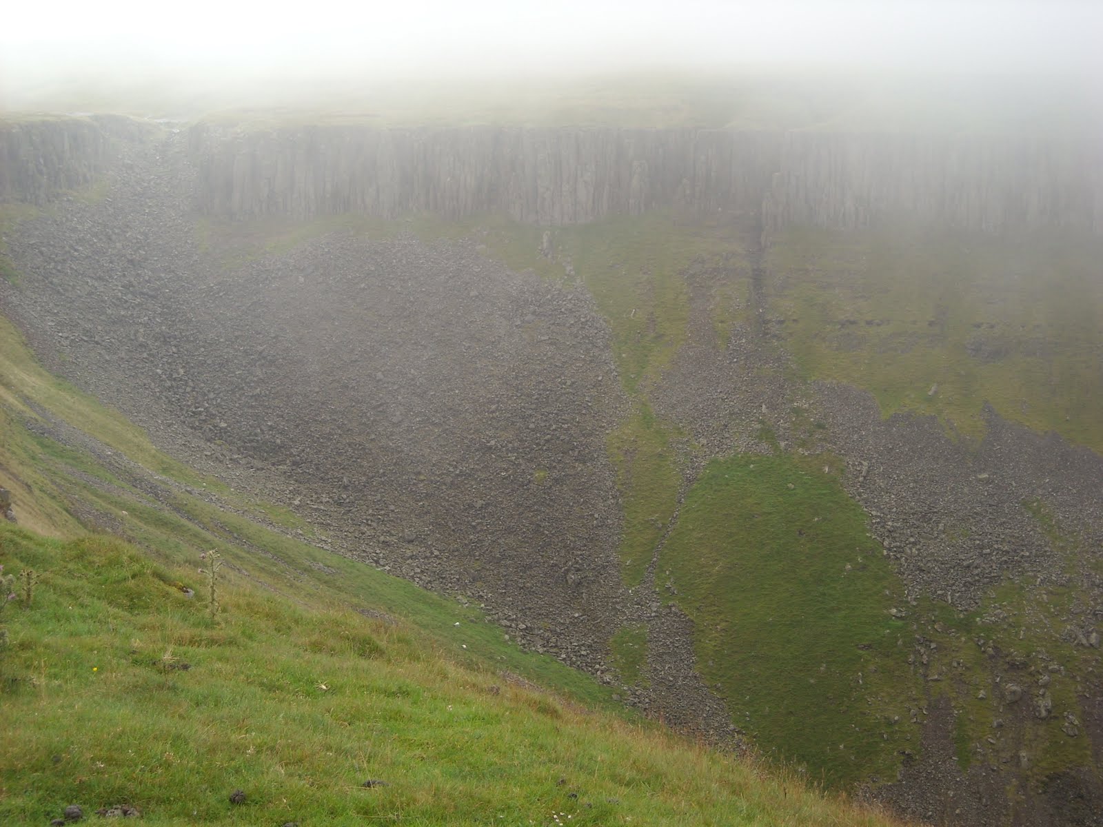
More rain on and off during the night. The temperature dropped quite low too. By this morning it was a thin drizzle driven by a blustery wind. Wispy clouds like torn remnants of lace where moving swiftly across the sky. Was in no big rush to get underway. Having a strip bath in the tent on a chilly morning is a tad masochistic but I prefer to be heading out with some semblance of cleanliness. An easy walk up to High Cup Nick. There are some lovely spots up there for a wild camp. The Nick is an impressive piece of geology; a mighty cleft cutting deep in to the surrounding high ground. Got a few odd looks from a couple passing by as I sat down in the drizzle, just happy to be drinking in the magnificent scenery. Thin misty clouds drifting through added to the atmosphere.

Footnote. Arrived back in London and walked straight in to a riot, mayhem on the streets; fire and smoke and the sound of smashing glass.
